Oregon fires update: 7,500 firefighters make progress, more residents can return
Officials reported more significant progress Sunday toward containment of 10 major wildfires still burning across Oregon, with a growing army of 7,500 firefighters assisted by cooler weather, higher humidity and recent rainfall.
More residents who fled the Holiday Farm Fire as it swept through the McKenzie Valley were allowed to return and see what survived.
The Oregon Office of Emergency Management said in its daily update the number of confirmed fatalities remained at nine and there still were five missing people.
The number of homes destroyed has risen to 2,267, with 1,556 other structures destroyed.
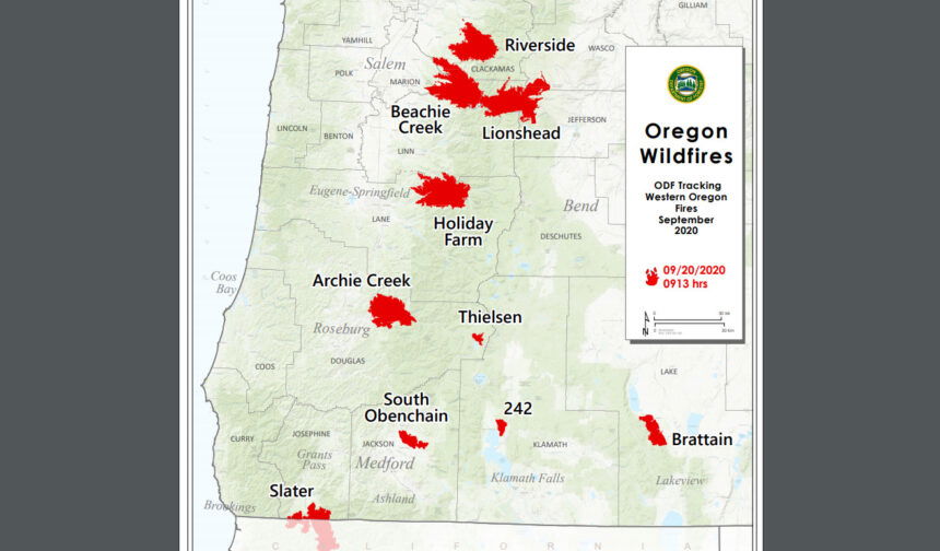
Oregon Dept. of Forestry Fire Report for Sept. 20, 2020
We are closely monitoring 10 major fires in Oregon, down from 17 originally (see table below for details). Fires are removed from the list when they are 100% lined and fire managers are confident in their progress toward containment.
There are more than 7,500 personnel assigned to these fires, not including many of the government employees, landowners, forestland operators, and members of the community who are contributing every day. There have been resources from 39 states and multiple Canadian provinces in this fight alongside Oregonians.
About 1 million acres have burned in Oregon since the start of this year, which is nearly double the 10-year average of approximately 557,811.
You can also check out the weekend fire status update video from Chief of Fire Protection Doug Grafe.
| Fire name | Acres burned (est.) | Containment | Location |
| Lionshead | 198,314 | 10% | 20 miles W of Warm Springs |
| Beachie Creek | 192,713 | 25% | 15 miles N of Detroit |
| Holiday Farm | 173,025 | 14% | 3 miles W of McKenzie Bridge |
| Riverside | 137,880 | 20% | 2 miles SE of Estacada |
| Archie Creek | 131,598 | 38% | 20 miles E of Glide |
| Brattain | 47,421 | 49% | 8 miles S of Paisley |
| Slater | 42,485 in Oregon | 18% | SE of Cave Junction (also in No. California) |
| S. Obenchain | 32,671 | 55% | 5 miles E of Eagle Point |
| Two Four Two | 14,473 | 64% | W/NW of Chiloquin |
| Thielsen | 9,703 | 22% | E of Diamond Lake |
Please note: The acres burned estimates above are based very limited information available. These numbers will change over the next several days, in some cases significantly. We will be taking every opportunity to map these fires. Fire maps are an important tool for both ongoing response operations and keeping people informed.
More information
- ODF wildfire blog and Significant Fire Potential Map
- Northwest Coordination Center – Regional Update and National Situation Report
Inciweb (information on individual incidents)
Lionshead Fire Update
Sunday, September 20, 2020 – 9:00 a.m.
Air Operations Active with Favorable Weather Conditions
Current Situation: Fire growth should be minimal today, with current weather and fire behavior forecasts. Fire behavior will likely increase with the warmer and drier weather in the coming days.
Resources from the National Guard will be arriving on the fire in the next few days. These troops, along with additional crews arriving, will allow for more work on the fire to be achieved.
Firefighting Efforts by Division:
On the northeast portion of the fire, in Division A, steep, rugged terrain and snags are present in the Badger Butte area. Crews were able to stitch together line and plan for filling in gaps in the line moving forward. The eastern fire perimeter in Divisions A and E is secure, but crews will continue to mop up and patrol for hotspots to achieve full containment. Good progress was made yesterday on direct line work to contain the fire spread to the north. The east side of the fire on the Warm Springs Reservation is approaching containment.
The east side of the fire in Divisions G, I, K, and N has been contained for several days. Firefighters will continue to monitor and patrol this area. Firefighting equipment, such as hoses, pumps, and portable tanks, that is no longer needed will be removed from this portion of the fire and relocated to other areas where there is a need.
On the southeast perimeter, working west from the Division N/R break (north of Jefferson Lake), the fireline has been secured west to the lava rock in Division R. To provide for firefighter safety, no crews have been placed on the active fire edge in the rest of this division or in eastern portion of Division S, east of the wilderness boundary, due to terrain and related safety concerns. Some rain on the area helped contain any spread on Saturday. Fire managers are monitoring this area with aircraft and drones with IR capability as aviation conditions improve. Air support will monitor any fire spread.
In Division S, within the wilderness, the fire has not moved in several days and is not currently posing a concern. This area is being monitored. On the west side of Division S, a combination of hand and dozer line is being constructed using the Whitewater Fire burn scar as an anchor point and tying into Highway 22. Line construction will continue west into Division T as terrain allows.
In Division T, the primary focus will be in the areas of Idanha, New Idanha, Detroit, South Detroit, and private lands to the south of the fire. Structure protection will continue in these areas. This portion of the fire received the most precipitation on Friday. The road system held the fire in this area, and this helped with further containment in the New Idanha and Idanha areas. Dozer line has been completed around the spot fire near Beard Saddle. The focus today will be containing a large spot fire near Stallman Point and the Cove Creek Campground.
On the northwest flank of the fire in Division W, fire managers are developing suppression plans for this portion of the fire. Continuing east to Division Y, in the finger of fire to the north, firefighters are focused on containing the spot fire and portion of the fire that crossed Highway 46. In Division Z, the immediate priority is containing a 600-acre spot fire that is near the Division Z/A break. Snags and difficult terrain have made this work difficult.
Two contingency groups are in place looking at options for indirect fireline. These lines will be used in the event that fire activity increases, and firefighters are not able to engage the fire directly. The south contingency group is working along County Road 12 creating fuel breaks along the road. This indirect line will be used to protect values to the east in the event fire activity increases in this area as fuels dry out. The north contingency group is working in close coordination with Riverside Fire management to identify opportunities to connect existing roads that both fires could use in the event these indirect lines are needed.
Thanks to the improved visibility, firefighters were able fly sections of the fire for the first time in several days. Having favorable weather has been extremely helpful in this regard. Helicopters were able to accomplish water bucket work and helispots for future work were identified. Due to local clouds and smoke, crews were not able to install the critically needed radio repeater scheduled for placement on the north side of the fire.
Weather & Fuel Conditions: Very mild conditions will continue for the next couple of days. Good minimum humidity during the day will limit fire spread in fine fuels. Friday's showers and thunderstorms that brought rainfall amounts around 0.3 inch to 0.5 inch west of the Cascade crest (approximately one inch fell near Detroit Lake) and 0.1 inch to 0.2 inch east of the crest. The rain helped to clear out the smoke that has blanketed the region for several days. Westerly winds allowed marine clouds to move inland toward the Cascade Range. Nevertheless, the air quality conditions greatly improved. No fire weather concerns are anticipated on Sunday. It will be warmer with lower humidity and little change in the winds. Highs on Sunday will be in the mid-60s to lower 70s, the relative humidity will range from 35 to 45%, and the winds will be west-southwest around 5-10 mph gusting to 15 mph.
Closures and Evacuations: Evacuation Notices remain in place for the Lionshead Fire. Level 3 “Go!”evacuation notices are still in place for the communities of Detroit, Idanha, and Breitenbush. There are no longer any evacuation notices for the Sid Walter/Miller flats area.
Roads and trails near the fire remain closed for public safety. This includes roads and trails on the Confederated Tribes of Warm Spring lands adjacent to the fire and a 40-mile section of the Pacific Crest Trail between Santiam Pass and Olallie Lake. Forest closures are in place for Deschutes, Mt. Hood and Willamette National Forests: Deschutes NF Alerts Willamette NF Alerts Mt. Hood NF Alerts.
Temporary Flight Restrictions: A Temporary Flight Restriction is in place over the Lionshead Fire and surrounding fires. Wildfires are a No Drone Zone. If you fly, we can’t. Whenever a drone is spotted near the fire all aircraft are grounded until we can be sure the drone is clear of the area. For more information, visit knowbeforeyoufly.org.
| Lionshead Fire Statistics: Size: 198,763 acres Containment: 10% Total Personnel: 1,077 Location: 14 miles west of Warm Springs Reported: 8/16/20, approximately 8:44 p.m. Cause: Lightning | For More Information: Information Office: 971-277-5075, 8 a.m. to 8 p.m. Email: 2020.lionshead@firenet.gov InciWeb: https://inciweb.nwcg.gov/incident/7049/ Facebook: facebook.com/LionsheadFire |
BEACHIE CREEK FIRE UPDATE – September 20, 2020
Acres: 192,714 acres
Percent Containment: 25%
Start Date: August 16, 2020
Cause: Under Investigation
Origin Location: Opal Creek Wilderness: two miles south of Jawbone Flats, six miles north of Detroit, Oregon.
Fuels: Timber and logging slash
Resources: 733
Additional firefighters and engines join Beachie Creek fire
Air resources flying again
Salem, Ore. – Five additional engines, another hot shot squad and crews from Canada join firefighting efforts Sunday on the Beachie Creek fire. These new resources will work to secure the southernmost edge of the fire. On the western fire perimeter, all crews remain hard at work and are making excellent progress securing lines to protect communities there.
As visibility has improved, the six helicopters and single engine craft assigned to the Beachie Creek fire have been able to fly. There is a Temporary Flight Restriction in place. The Southwest Area Type I Incident Management Team also assisted Bonneville Power and other utility firms to assess and access the electric grid, including 11 substations, 266 miles of transmission lines, and 122 communication towers.
Sunday and Monday bring dryer air, warmer temperatures, and lower humidity. This means that residents may see smoldering fire, potential torching, and smoke from the interior of the fire’s footprint. As residents of Mill City and Gates return, they should know that there are several places inside of the fire, called green islands, that did not initially burn. The rain did not put out the fire, and it is still slowly smoldering, consuming those green islands. That activity is well inside of the fire containment lines, and first responders are aware and working the scene.
The primary focus Sunday and Monday will be putting firefighters directly on the fire lines and reinforcing those containment lines, contingency lines, and monitoring any hot spots to protect Marion and Clackamas Counties, especially on the Western edge, including Greg’s Corner, Silver Falls State Park, and to the north, Corbet’s Corner. Sunday 260 Canadians joined the Area Command; half are assigned to the Beachie Creek fire. They will build fire line along State Route 22 between Stayton and Detroit. State Route 22 has roadblocks; first responders and ODOT are working to clear fallen trees and rockslides.
Fire officials also continue to work closely with the Marion County and Linn County Sheriff’s Offices, ODOT and the Oregon State Police to coordinate residents’ return to Santiam Canyon. Currently, 1,118 structures are at Level 3 evacuations and another 4,574 are in level 2 evacuations. As more residents are allowed back into the area, it is imperative that everyone heeds road closures and safety messages. Anyone who enters the fire perimeter jeopardizes firefighting operations and puts lives at risk.
The Willamette National Forest, Bureau of Land Management, and State lands around the fire remain closed to the public. Go to InciWeb.gov for more information about closures in the area.
| Public Contact Information: Facebook.com/BeachieCreekFire2020 Email: 2020.beachiecreek@firenet.gov Phone: 541-583-0526, 8 a.m. to 8 p.m. | Inciweb https://inciweb.nwcg.gov/incident/7001/ Smoke and Air Quality http://oregonsmoke.blogspot.com/p/air-quality-now.html https://wildlandfiresmoke.net/outlooks |
Holiday Farm Fire Information
September 20, 2020
Oregon Department of Forestry IMT 3
Link Smith, Incident Commander
Holiday Farm Fire Information: (541) 357-9729 (7am—9pm)
Lane County Non-Emergency Call Center: 541-682-3977 (7am-9pm)
Linn County Non-Emergency Call Center: 541-812-2260
https://inciweb.nwcg.gov/incident/7170/ email: holidayfarmfireinfo@gmail.com
Springfield, Ore. – Many residents that have been under a Level 3 Evacuation (GO) since the night the Holiday Farm Fire started on Labor Day can now return to their homes. The area previously under a Level 3 Evacuation has dropped to a Level 2 Evacuation Notification (Be Set).
For more information on current evacuation
levels, visit www.lanecounty.org/mckenziefire for Lane County and
www.linnsheriff.org/fire_live_updates_sept_2020/ for Linn County.
Please continue to monitor cell phones, landlines, local media and official information sources for evacuation updates. Fire managers request that the public please avoid the area.
Fire crews continue to make excellent progress around the 260-mile perimeter of the fire. Heavy mop-op operations are underway in several areas throughout the fire.
While the terrain, combined with the recent thunderstorm showers, has posed challenges for fire crews to gain direct access to the fire’s edge, they are taking advantage of the cooler weather to tighten up fire lines and keep the main fire from spreading much further.
A primary focus today will be near and around HJ Andrews Experimental Forest, just outside the northeast corner of the fire’s edge. Depending on weather, smoke and cloud cover, firefighters may be aided by a Type 1 helicopter capable of dispensing up to 3,000 gallons of water with each drop. A total of seven helicopters will be available throughout the fire area if needed.
Roads remain closed in the fire area and much of the Willamette National Forest (WNF) and Northwest Oregon District BLM. Road hazards include falling trees and rocks and debris. For more information on closures on the WNF, visit:
https://www.fs.usda.gov/alerts/willamette/alerts-notices/?aid=61574
For more information on closures on the Northwest Oregon BLM, visit:
https://www.blm.gov/press-release/extreme-fire-activity-prompts-closurebureau-land-management-lands-northwestern-oregon
Two Four Two Fire
September 20, 2020 11:00 a.m.
Oregon Department of Forestry IMT 2
Bill Hunt, Incident Commander
Email contact—twofourtwofire.information@gmail.com
Public Information Line: (541) 846-8174
Inciweb—https://inciweb.nwcg.gov/incident/7159/
Facebook—https://www.facebook.com/TwoFourTwoFire/
Size: 14,473 Acres
Containment: 64%
Start Date: Sept. 7, 2020
7:00 p.m.
Expected Containment Date: Sept. 25, 2020
Location: Northwest of Chiloquin, Oregon
Cause: Unknown
Est. Cost: $6 million
Personnel: 411
Resources: 8 hand crews
26 Engines
6 Dozers
11 Water Tenders
Aircraft: 3 Helicopters
Evacuations: None
Structures
Threatened: 0
Structures
Damaged: 33
Structures
Destroyed: 48
Closures: None
Fire Summary:
There will be a virtual community meeting via Facebook Live at 7pm tonight. Hear from incident leadership and community leaders on successes and resources available for support after the fire. This will be the final community meeting.
Firefighters worked throughout the day yesterday extinguishing heat
next to the containment line. This is labor-intensive work as they dig out stump holes and open up dozer berms to expose buried heat under the dirt.
Last night, crews continued to patrol for visible hot spots along Highway 97 and Highway 62. Crews worked through the night to extinguish what they could and marked areas they did not get to for the day shift.
It will be warmer and drier with light winds over the fire area today. The
extended weather forecast shows an increasing chance of precipitation over the fire late this week.
Firefighter and public safety is the priority during this incident, including
COVID mitigation. Personnel will be following Center for Disease Control guidelines to limit personal interactions both within camp and with the local community. The incident command post and fire camp are closed to the public and media.
BRATTAIN FIRE UPDATE
September 20, 2020 @ 9 AM
Yesterday:
Lines in all areas of the fire seem to be holding well. There is still a lot of heat on the interior, and smoky conditions continue, with most smoke coming from about 200 acres burning on the interior in the northwest corner of the fire. Mop-up and line patrol operations were a focus, and there was no major fire perimeter growth. Cooler temperatures moved in, making conditions favorable for operations to shift resources and allow us to move into more of a rehabilitation mode. Strategic burning operations moved into a more occasional status instead of constant. We held a virtual community meeting on Facebook, so if you missed it you can still view it on our Facebook page @R6FWNF.
Today:
Fire managers were able to lower the profile of night operations last night, a positive development. Expect the same creeping and smoldering we saw yesterday, with smoke mostly coming from the interior in the northwest corner of the fire. We will continue mop-up and patrol lines in all divisions. Firing operations will be used to hasten burning of unburned fuels in the interior islands to reinforce fire control lines. Mild, southwest terrain-driven winds are expected. Higher humidity is expected this morning, with temps warming in the afternoon and humidity lowering to around 15%. No red flag warnings are expected. We are moving into more active repair/rehab operations, and a special rehab module is being mobilized to focus specifically on these activities. Crews have four or five more days of activity before a reduction in personnel will occur.
Evacuations:
The Lake County Sheriff’s Office has updated the following evacuation notices:
Level 3 (Go) – South of the Murphy Ranch on Clover Flat Road east to Valley Falls
Level 2 (Set) – Highway 31 from Summer Lake Store south to Red House Lane, all of Paisley to Valley Falls; Clover Flat Road from Hwy 31 (Beachler’s Corner) to Murphy Ranch
Level 1 (Ready) – Highway 31 from Summer Lake Store to Picture Rock Pass; Highway 395 from Valley Falls east to Chandler State Park
The Red Cross has closed the evacuation area at the Lake County Fairgrounds.
Forest Closure:
From Forest Road 29 southeast to Forest Road 3510 and the 28 Road east, all National Forest System lands and facilities are closed per Forest Closure Order 06-02-03-20-03. Forest Road 3315 is closed; the 28 Road is open.
SAFETY:
Hwy 31 is open but anticipate heavy fire traffic. Avoid the area if possible.
Temporary Flight Restrictions are in effect. Avoid drone use and report drones to law enforcement.
Summary:
The Brattain fire started on September 7, 2020 and is currently burning on the Paisley Ranger District of the Fremont-Winema National Forest. The Eastern Area Incident Management Team is currently managing the fire. Firefighting crews continue to operate on a 24-hour schedule and are battling winds, extremely dry conditions and shortages of firefighting resources.
SIZE: 50,409 acres
CONTAINMENT: 49%
CAUSE: Human
PERSONNEL: 498
FIRE INFORMATION:541-947-6243
Email: 2020.brattain@firenet.gov
INCIWEB:inciweb.nwcg.govsearch “Brattain Fire”
Facebook:facebook.com, search:Fremont-Winema National Forest @R6FWNFSouth Central Oregon Fire Management Partnership @SCOFMPFIREINFO
Emergency Fire Closures on the Fremont-Winema National Forest
LAKEVIEW, Ore. – There are currently three emergency fire closure orders in place on the Fremont-Winema National Forest associated with fire activity and incident management, as well as the Public Use Restrictions.
Both the Two Four Two Fire on the Chiloquin Ranger District and the Brattain Fire on the Paisley Ranger District have had updated closure orders in place since September 13.
For the Two Four Two Fire, Closure Order 06-02-12-20-01 includes all National Forest System lands north of State Highway 422 North, up to the junction with Forest Road 9734 and U.S. Highway 97, and from as far east as Williamson River Campground to as far west as the edge of Wood River Day Use Area.
For the Brattain Fire, Closure Order 06-02-03-20-03 is bounded by Forest Road 29, also known as Government Harvey Road, on the north end to Forest Roads 3510 and 33 on the south end, with all three roads closed in those areas. The closure extends from the Forest Boundary west to Forest Road 28, with the 28 Road remaining open. Forest Road 3315, also known as the High Road, outside Paisley is closed, as well as Forest Road 3510-018 off of Clover Flat Road.
Both closures are directly related to active and ongoing firefighting activity, including mop-up and repair work. Even where there is not active fire, there are still hazard trees and other dangers that require the areas to be closed for public safety.
“Even though there has been tremendous progress by the firefighters and incident management teams over the past two weeks, we still have many areas where the fires are burning and will continue to do so until season-ending rains and winter snow,” said Fremont-Winema National Forest Deputy Supervisor William Dunk.
“There will still be visible smoke as pockets of vegetation burn and the fire areas have numerous hazard trees in them,” Dunk said. “These areas are not safe right now and we are asking the public to respect the closure orders and allow firefighters to continue their suppression, mop-up and repair work safely.”
The Crane Fire area on the Lakeview Ranger District remains closed as pockets of fuel in the fire’s interior continue to burn in rugged, inaccessible terrain. That closure is Order Number 06-02-20-02-02 and went into effect on August 27.
Additionally, another closure went into effect on Friday in support of the Thielsen Fire currently burning on the Umpqua National Forest.
Closure Order 06-02-11-20-01 closes Forest Road 9772 between U.S. Highway 97 and Forest Road 9772-110, including Walt Haring SnoPark, as part of the organizational and public safety needs of the Incident Management Team assigned to the Thielsen Fire.
Miller Lake and Digit Point recreation sites are still open through a detour using Forest Road 9774 off Highway 97 north of Chemult, then left on Forest Road 9772-110 south to Forest Road 9774 and then turn west towards the recreation sites.
Firefighters have been working hard since the Two Four Two and Brattain Fires started on Labor Day. Local resources have responded to additional fires in the area over the past two weeks. Despite cooling temperatures and the start of fall, conditions in the forest continue to be unusually dry.
The Forest is still under Public Use Restrictions and in the extreme fire danger category. Those recreating in the forest are asked to comply with current fire restrictions, which includes limiting campfires to fire-rings in approved sites.
The public is urged to use caution with anything that can throw a spark and to strongly consider whether a campfire is necessary, including in the approved sites. If there is a campfire, please don’t leave it unattended and make sure it is drowned, dead-out and cold to the touch before leaving.
Anyone driving near the Two Four Two and Brattain Fire areas should watch for increased traffic and vehicles associated with wildland firefighting.
Violations of any of these closure orders – including the Public Use Restrictions – are punishable by a fine of not more than $5,000 for an individual or $10,000 for an organization, or imprisonment of not more than 6 months or both.
All closure orders can be found on the Fremont-Winema National Forest website at www.fs.usda.gov/fremont-winema under “Alerts and Notices”.
For more information on the Fremont-Winema National Forest, visit www.fs.usda.gov/fremont-winema, follow the Forest on Twitter @FremontWinemaNF or on Facebook at www.facebook.com/R6FWNF.